Thursday, June 7, 2018

Glen Canyon Rafting

Although whitewater rafting in the Grand Canyon looks like an amazing experience (and I hope to do it someday), a whitewater river trip in Glen Canyon--just upstream from the Grand Canyon--is easier to do without much prior planning. And it's absolutely beautiful. It might have been my favorite day of the trip, although it's so hard to choose.

The river trip starts at the Glen Canyon Dam. Glen Canyon was first considered as a dam site in the 1920s, but Hoover Dam, downstream of the Grand Canyon in Black Canyon, was built instead. A few decades later, it was decided that additional reservoirs were necessary to support the growing population. Glen Canyon Dam--built between 1956 and 1966--holds back the Colorado River, flooding upper Glen Canyon to form Lake Powell, the second largest man-made reservoir in the country (after Lake Mead, formed by Hoover Dam).

The dam is 710 ft (221 m) tall. To reach our launch site, at the base of  the dam,
we were driven through a two mile tunnel that was built before the dam construction began.

Glen Canyon Dam is highly controversial for many reasons. The construction of this and other dams along the Colorado River has altered the river dramatically. But while some effects, such as the Colorado rarely reaching the sea, seem highly problematic, there are also benefits, such as irrigation for crucial agricultural areas and the 4.5 billion kilowatt hours generated annually by the Glen Canyon Dam alone. And then there are the mixed effects, such as the ecology of the river and canyon.


For example, the Colorado was so named because of its red color, due to the sediments it carried. It was these sediments that made the Colorado River so effective at carving canyons through the landscape: the sediment-laden water acted like abrasive sandpaper. Combined with seasonal flooding, this prevented any stable beaches or vegetation from forming in the canyon. The creation of the dam has held back the silt, turning the water blue-green, and limited variation in flow rates. This has led to problems for some species, such as endemic fish species that were adapted to the pre-dam Colorado River, and advantages for others, such as all those that rely on the narrow beaches, grasses, and trees that now line the river. I suppose that's all to say, "It's complicated".

Now back to the trip, and of course the photos. Still within sight of the dam, we saw ospreys (Pandion haliaetus). The first was in its nest, head barely visible.


The second was flying. It soon landed on a pole, on the opposite bank from the nest, where it stayed for quite a while. I only noticed later, looking at the photos we took, that it was carrying a fish!


We saw several great blue herons (Ardea herodia) along the way, wading in the water, flying along the river, and perched above us, looking down.


As the wet season is still a couple of months away, there was little water coming down the sides of the canyon, at least visibly. But we did see one little waterfall. At the height of monsoon season there are countless waterfalls along the cliffs.


All of this greenery is a good example of what would be tumbled away by an undammed river. You can also see some slight turbulence in the water here.


Take a look at the canyon walls below. See those two huge gouges that look a little bit like eyes? Those were caused by giant boulders carried along by the Colorado cutting into the surrounding rock.


Most of the trip was filled with gorgeous views like this one. I struggled to limit the number of photos I included here, but like the Grand Canyon, every angle and perspective was interesting and different.


Another great blue heron.


And another wader, of a different ilk! A man fly fishing.


Although many stretches of the canyon walls are smoother, this section was rather columnar.


These arch-like features in the walls are very common. They are areas where the rock face has collapsed, leaving crumbled pieces at the bottom and this interestingly shaped depression in the wall above.


One of the highlights of the river trip was so-called Petroglyph Beach, where we had the chance to wade or swim in the river. The water downstream of Glen Canyon dam is extremely cold, because the water released through the dam comes from the bottom of Lake Powell. It is 47 degrees Fahrenheit (8.3° C) when released and warms only about one degree per 20 miles. But it feels good (briefly) on a hot day.


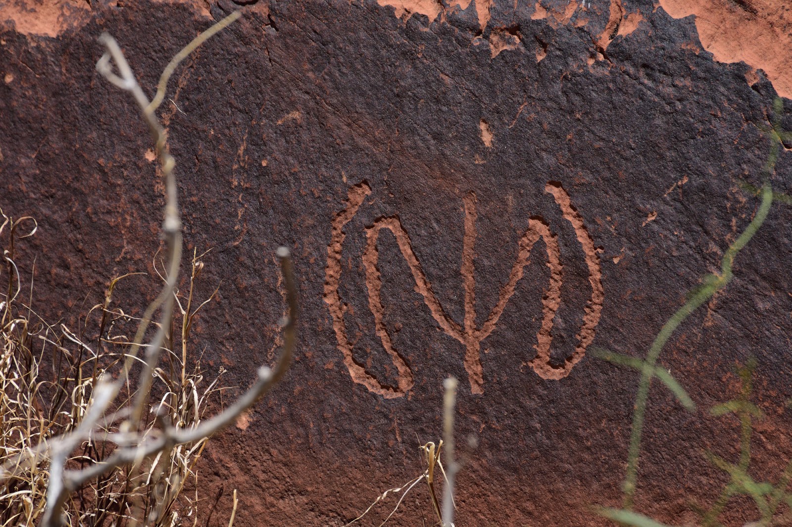
The other attraction of Petroglyph Beach is, unsurprisingly, the petroglyphs. Most are zoomorphic and have been etched into the dark rock varnish.


Rock varnish is the dark layer on the surface of the rock, composed mostly of silica, and formed by exposure to the arid environment.


\
While the petroglyphs were etched by humans, the river has etched its own figures into the canyon walls. We enjoyed pointing out ones that looked like something recognizable, much like is often done with clouds. This one looked like some sort of mythical creature to me (maybe part hedgehog?).


Here are some more views of the canyon itself, as we floated slowly down river.


I am always so impressed with how plants can grow in the seemingly most inhospitable circumstances.


On the south side of the river is the Navajo Nation. Fun fact: although Arizona does not observe daylight saving time, both Utah and the Navajo Nation do, making automatic time settings on phones rather unreliable in this area. The Navajo Nation is roamed by mustangs, feral (not wild) horses that are descended from domesticated horses that were introduced to the Americas by the Spanish.


The trip ends at Lees Ferry, the dividing point between the Upper and Lower Colorado Basin, and the end of Glen Canyon. It is one of the only spots in the region where the Colorado is not surrounded by towering cliffs, making it a great place for launching and docking boats. While this was the end of our river trip, it is also the starting point for the Grand Canyon whitewater rafting trips, now officially on my list of things to do when I return to the Grand Canyon.


Sunday, May 27, 2018

Grand Canyon: First Glimpses

With the semester over, a friend and I drove north to the Grand Canyon for a few days. Neither of us had been before. And wow, was it spectacular. The photos here are from just the first evening--our first glimpses before returning to Kaibab National Forest to camp--taken from Mather Point and the surrounding area. There are many more to come. (To browse a gallery of the images larger than shown below, click on any photo.)

It's impossible to capture just how vast the canyon is. Just one-third of the canyon is visible from Mather Point. Here is one view, from the so-called South Rim, looking north-northwest...


And another, looking approximately east-northeast.


USGS geologist Clarence Dutton studied the Colorado Plateau region in the late 19th century. He thought that many of the rock features in the canyon resembled ancient temples from the Middle East and Asia, so he named the features accordingly. Personally, I think it's a bit of a stretch--admittedly more so for some than others--but I enjoyed trying to identify them nonetheless. 

In the center is Isis Temple, slightly to the right is the flat-topped Cheops Pyramid, and the white peak toward the right (east)
is Buddha Temple. The peaks of both "temples" are over 7000 ft (2100 m) above sea level, similar to the rims of the canyon.

Further to the east is Zoroaster Temple, the white peak left of center.

Part of the south rim in the foreground and Isis Temple in the background.

You hear a lot about the rock layers (strata) in the Grand Canyon, which accumulated over millions of years and embody the geological history of the region. As spectacular as they are (I'll share more about them soon), visually I was just as struck by the effect of layers upon layers of canyons, valleys, cliffs, and peaks, receding into the distance.

Behind and to the left (west) of Isis Temple is Shiva Temple,
and further left are The Temple of Osiris and Tower of Set. 

Cedar Ridge extends northward from the south rim (bottom right), topped by O'Neill Butte,
and culminating in Skeleton Point.

Topping Cedar Ridge is O'Neill Butte. The strata are particularly visible here.

As impressive as the panoramic views are, looking down into every nook and cranny is just as satisfying. There is something of interest in every direction.


Under the harsh Arizona sun, the light shows the gorgeous colours of the canyon, but the shade is always a relief. The contrast between the glowing and shaded rock is both beautiful and a challenge a for photography.


Shadows of people positing for pictures look a little bit like rock art.

The forest goes right up to the edge of the canyon and then down the side, changing with the elevation along with the temperature and precipitation gradients. I'll tell you a bit more about the ecology later, with photos of most of animals and wildflowers that we saw throughout the week.


Friday, April 6, 2018

Montezuma Castle

So-called Montezuma Castle is a National Monument between Phoenix and Flagstaff. It is neither related to the Aztec ruler Montezuma nor a castle. It is a site with multi-level pueblos, including cliff dwellings. And it is spectacular.


The dwellings were built and inhabited by the Sinagua people over several centuries, from approximately 1100 to 1425.


The site actually includes two different "castles" side by side. The first, is itself called Montezuma Castle. It is five stories tall and built into the side of a cliff face.


Montezuma Castle is approximately 90 feet (just under 30 m) off the ground and would have been accessed by ladders.


The second dwelling is known as Castle A, which is thought to have had 45-50 rooms.


One of my favorite things about the site in general, and especially Castle A, is the way the masonry and the cliff blend into each other.


The surroundings are, not entirely coincidentally, gorgeous. The cliffs border Beaver Creek, which as a source of water in the desert, made the area particularly habitable and more suitable for agriculture.


The river also provides enough water for sycamores, in this case the Arizona sycamore (Platanus wrightii). With their tall white trunks, sycamores are some of my favorite trees.


The sycamores were used to make the structural beams, some of which are visible.


And here's one final look. Isn't it stunning?