Thursday, January 14, 2021

Blackett's Ridge: Birds, Deer, and Adorable Chipmunks

Last week I did one of the more challenging short hikes in Sabino: Blackett's Ridge. It's about 6 miles roundtrip, and while the first mile from the parking lot is quite flat, the next two miles climb over 1765 ft (or 538 m; for scale, One World Trade Center in New York City is 1,792 ft including the spire, but the roof is only 1,368 ft tall). It was great exercise, and there were lovely views, but it was a particularly good morning for wildlife.

First, there were the mule deer (Odocoileus hemionus). We saw at least four different individuals in two groups of two.

Then there were the birds, including this lovely cactus wren (Campylorhynchus brunneicapillus) perched on a tree branch.

And this phainopepla (Phainopepla nitens), perched atop the neighboring tree.

The route is steep enough that I required frequent pauses to catch my breath. But there were lovely views to take in while I did so. Those of you who read my post about my Wasson Peak hike might remember that I mentioned Kitt Peak; although Sabino is even further away, from this angle you can see more of the observatory, including the solar telescope (the angular structure to the left of the shinier domes; click on the image to look more closely). The Tucson mountains and part of the city are in the midground.


Reaching the top of Blackett's ridge definitely felt like an accomplishment, which is particularly appreciated in these times (and really in graduate school generally).


At the top there are lovely views of both Bear Canyon and Sabino Canyon, as well as the Catalinas.


And especially "Thimble Peak".


But perhaps the best part about reaching the the end of the trail were these extremely cute cliff chipmunks (Tamias dorsalis). They were clearly used to scavenging the crumbs of hikers' lunches, whether left intentionally or unintentionally (note: please don't feed wildlife!). 


I could easily have sat there for hours photographing these adorable creatures.


But eventually, we headed back down, much more quickly than we had clambered up. Once we'd reached the road again, we saw this male cardinal (Cardinalis cardinalis) hopping around on one of the bridges. This isn't the conventionally best photo, because of the angle of the light, but I like that it captures how the crest was brilliantly illuminated in the sunlight, outshining the rest of his plumage.


And here's the same individual, just a few moments later.


Just a little ways on--near the end of the hike--my friend suddenly put her hand out to stop me from walking any further. There was a roadrunner (Geococcyx californianus) right in the middle of the road and walking towards us. (Side note for folks in Tucson: in my experience, Sabino canyon is the place I most frequently see roadrunners!)


We stood still and let it run on by...


Sunday, January 10, 2021

Wasson Peak: All the Views

I meant to get this blog post up several days ago but was distracted by the terribleness of the week. Nevertheless, both spending time outside and looking through photos of nature are great coping strategies and distractions from doom scrolling, so here it goes (finally). 

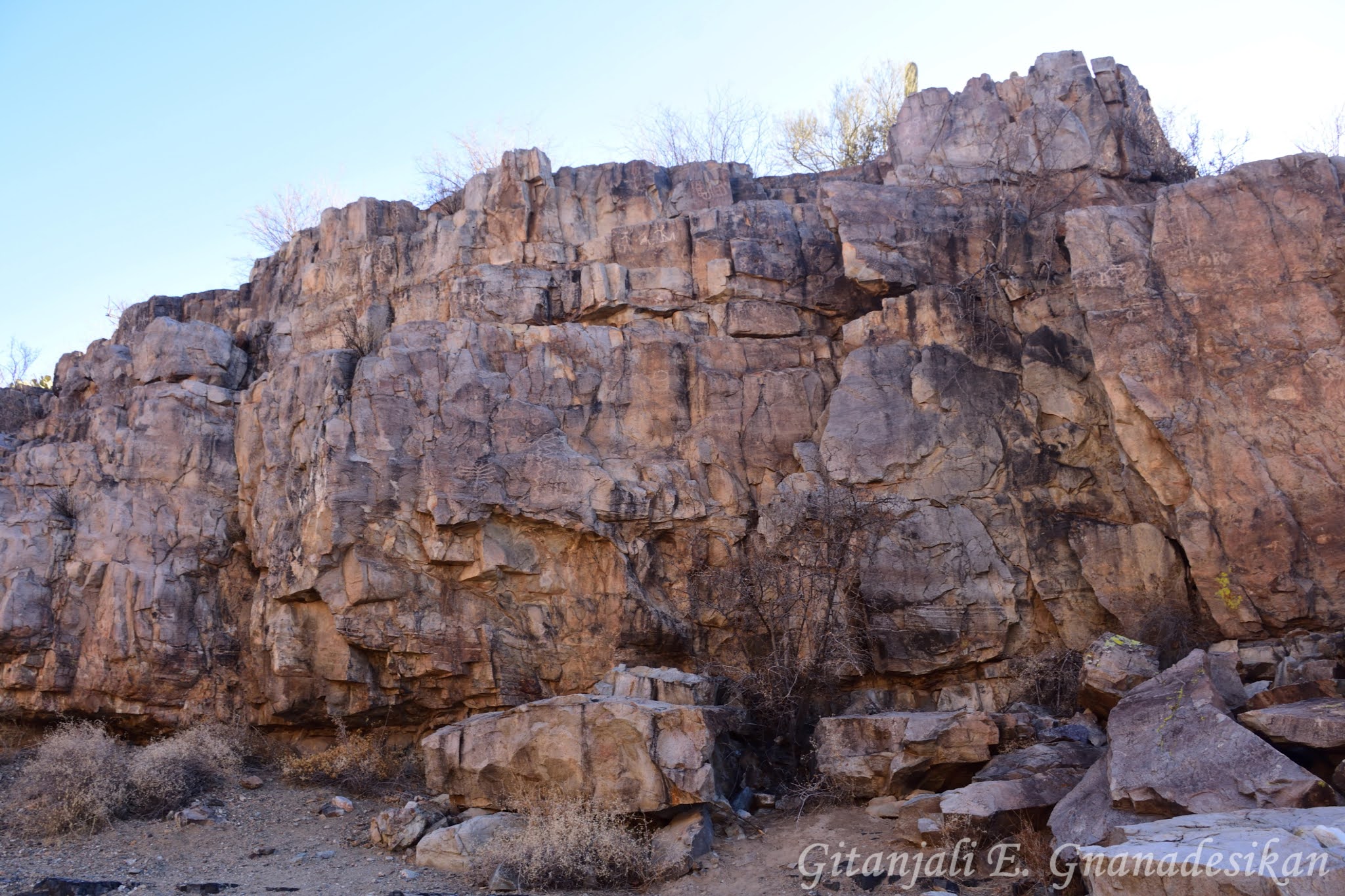
Almost two weeks ago now, I hiked Wasson Peak, which at 4,687 ft (~1430 m) is the tallest peak in the Tucson mountains, although the Tucsons are the shortest of the mountain ranges surrounding the city of Tucson. We started on King's Canyon Wash (the site of beautiful petroglyphs), then took King's Canyon Trail up to the peak, and then back down via Hugh Norris, Sendero Esperanza, and Gould Mine trails.


Relatively early in the hike, there were lovely views of Kitt Peak National Observatory in the Quinlan Mountains on the Tohono O'odham Nation. Kitt Peak is home to more than 20 telescopes, including what was until recently the largest solar telescope in the world (recently surpassed by the Inouye Solar Telescope). If you look carefully, you can make out two distinct telescope domes.


Further along, there were several sections of the trail with stunning lichen assemblages. Okay, I'll admit, I have a soft spot for lichen. Sorry to bore you if you're not a lichen fan... but really, you should be.


This is Wasson peak, viewed from just downhill to the north. It's not a particularly impressive peak itself, but it has magnificent panoramic views.


This is the view looking southeast across Tucson, including all the surrounding mountains, from the Catalinas in the north (left-most), through the Rincons, the Santa Ritas (middle, background), and the Baboquivari and Quinlans (right), with most of the rest of the Tucson mountain range in the foreground.


I love the texture of the Tucson mountains, which has been shaped over millennia by quite a lot of volcanic activity


Zooming in a bit on the right side of this view, there's a nice clear view of Gate's pass, which is the main road that crosses the mountain ridge and a favorite spot for sunset viewing.


From the summit you can also spot Old Tucson at the foot of Gate's pass. Only recently closed to the public, Old Tucson Studios was both a theme park and the shooting location for hundreds of films and TV shows for decades, especially--but not exclusively--for Westerns.


Here's one more view off to the south, with some high desert vegetation in the foreground, including ocotillo (Fouquieria splendens), cholla (Cylindropuntia, I'm not going to guess the species, especially given how much they hybridize), and agave (maybe Agave schotti?).


And this is the view looking northwest from just beneath the summit.


After some exploring in Google Earth, I think I've identified these as Panther and Safford Peaks. And just to the left of them is a limestone quarry. Here's a fun--if a bit sad--piece of local trivia for you: just to the north is "Twin Peaks Rd" (also an exit off of I-10), named for a now non-existent pair of peaks. Well, one of them is still there, but the other has since been mined away for cement.


And even further into the distance you can just make out Picacho Peak. In addition to be a visually striking peak, Picacho was home to the westernmost battle of the civil war. It's right off of I-10, so I've driven past it many times, but never (yet) stopped.


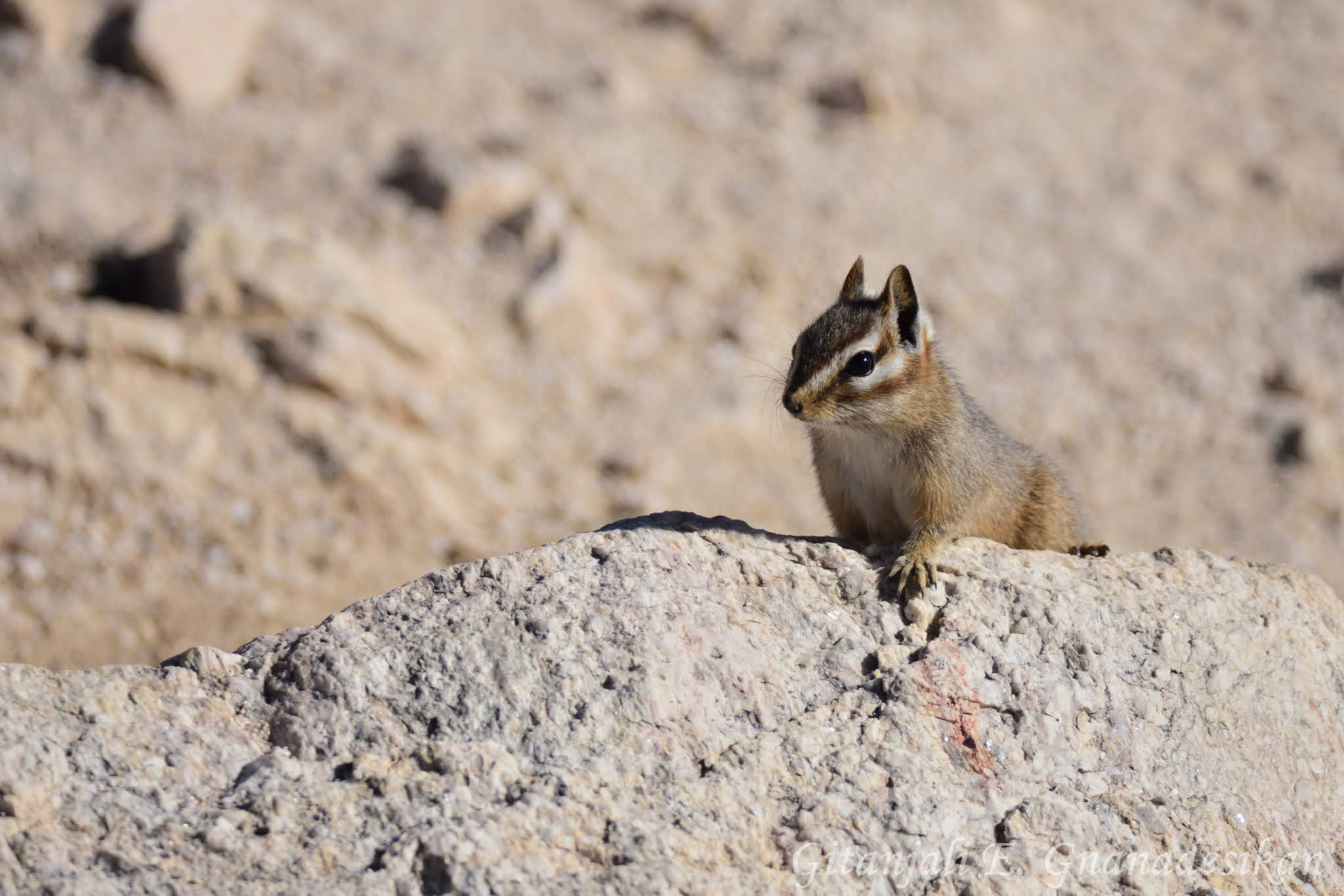
We saw a few birds on the hike, including what I think was a northern harrier hawk (Circus hudsonius, not pictured). While we lunched on the peak, though, we were visited by two different species of wrens. First, the cactus wren (Campylorhynchus brunneicapillus) with it's darker head, white stripe, and speckled appearance. Here's one, seen first perching--quite appropriately--on a cholla.


And next, the rock wren (Salpinctes obsoletus), which is much paler.


This is another species of cholla, sometimes fondly known as teddy-bear cholla (Cylindropuntia bigelovii) due to it's fuzzy appearance, although of course it's far from soft.


Since this was, after all, Saguaro National Park, I'll leave you with a lovely old saguaro, surrounded by hundreds of younger individuals in all directions.


This was definitely a hike I'd both recommend and happily do again sometime soon!

Sunday, January 3, 2021

Petroglyphs: King's Canyon Wash

Last week I hiked Wasson Peak, which is the highest point in the Tucson mountains, the range west of the city of Tucson. The first mile or so of the hike--starting right across the road from the Arizona-Sonora Desert Museum--was along the King Canyon Wash, which I highly recommend for anyone who appreciates petroglyphs. You can also hike just the wash as a short ~2 mi round-trip trek without continuing on to the summit. 

There are stunning panels on either side of the wash, full of various geometric, zoomorphic, and anthropomorphic images etched into the rock patina. I assume that these--like most of the rock art in this region--were created by the Hohokam people. The Hohokam lived in this area for well over a millennium before Spanish contact and are well known not only for their petroglyphs but also for their canals, some of which have since been incorporated into the Salt River Project. Descendants of the Hohokam people, including the Tohono O'odham, still live here in Tucson and throughout southern Arizona.

Here is just a small sampling of the petroglyphs in King's Canyon. This was the first set my friend spotted, but upon closer inspection, we found that they covered many of the surfaces of the canyon along this stretch of the wash.


This particular wall was particularly impressive. How many petroglyphs can you find in this photo before I zoom in on smaller sub-panels?


And just when I thought maybe we'd found them all and was getting ready to put my camera away and continue hiking, I saw another whole set on the opposite side of the canyon.


Some of the petroglyphs have relatively obvious referents, especially some of the zoomorphic ones such as these ungulates (only one is really crisp and clear, but I think there are a few more below it).


Others can be a little less clear, whether because they are more abstract or because they have faded or been damaged over time. But I think this one might be a snake?

If you enjoyed these petroglyphs, I previously posted photos of other Hohokam petroglyphs from a couple of nearby sites that I visited almost two years ago. All of these sites are relatively accessible without too much hiking. If you do visit them yourself, just remember not to touch them! The oils on our hands can damage the petroglyphs. 

More photos of the rest of the hike will be coming soon, including lovely panoramic views with about a hundred miles of visibility!